
C2 Utility Stats Searches & Composite Drawings
Before designing a route for a pipeline, cable or road corridor, planners need a clear picture of what’s already below ground along the entire length, not just at a single point. A C2 utility stats search gathers records from statutory undertakers covering your specified area, giving you documented information on buried services and obstructions to inform that planning process, before a single metre of the route is finalised on paper.
Built for Route and Corridor Planning
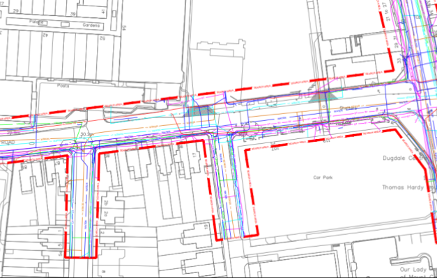
Unlike a single-site utility search, C2 searches are often commissioned for linear or extended areas, such as a proposed pipeline route, cable corridor or access road, where the area of interest could run for hundreds of metres or several kilometres rather than sitting within a single site boundary. Our composite drawings bring together records from multiple utility providers along that route into a single overlay, typically plotted onto a topographical survey or OS Tile, giving route planners and engineers one clear reference rather than a stack of separate provider records to cross-check individually. This matters particularly on longer routes, where a corridor may cross the network boundaries of several different utility companies, each holding records in a different format, at a different scale, and updated at different times.
Interpreting Records From Multiple Providers
Utility records supplied by statutory undertakers vary considerably in quality, some are detailed and recently updated, others are historic, incomplete, or recorded to a scale too coarse to be genuinely useful for route design. Our team reviews and interprets these records as they’re received, resolving inconsistencies between providers where routes or crossings overlap, and flagging areas where record quality is poor enough that on-site verification, such as a PAS 128 Survey or trial hole, would be worth commissioning before construction begins. This interpretation step is where genuine value is added, a raw stack of utility company responses on their own can be difficult for a route designer to use with any confidence.
Accredited for Work Across Live Infrastructure
Subvision Surveys is approved by SafeContractor, CHAS and Construction Line, alongside our SSIP and ISO accreditation, reflecting the standards expected when working near existing utility infrastructure during route planning and design. Our team combines this with years of practical experience interpreting utility records, many of which vary significantly in format and accuracy between providers, giving route planners a dependable starting point rather than a raw data dump to work through themselves.
Why Choose Subvision for C2 Utility Stats Searches
Subvision Surveys is SSIP and ISO accredited, and approved by SafeContractor, CHAS and Construction Line, giving route planners and engineers confidence in the standards behind every search and drawing we produce. With more than 3 decades of experience interpreting utility records from providers across the UK, we combine desktop searches with our PAS128 Utility Mapping Surveys and Virtual Trial Holes where a route or site requires on-site verification, giving you a route from desk-based records through to confirmed, physical detection under one team.
Contact Subvision Surveys today to discuss a C2 utility stats search or composite drawing for your project, or speak to one of our experts on 0333 920 942.
C2 UTILITY STATS SEARCHES & COMPOSITE STATS DRAWINGS FAQ’S
